Boyonabike!

Life beyond the automobile in Southern California

Archive for the tag “Pasadena DOT”

Sierra Madre Villa Bike Lanes

When local governments do little to make their cities bike and pedestrian friendly, I have often been quick to criticize. Sometimes I do a lot of criticizing, because so much still needs to change to enable the transition to a healthier, safer, more sustainable, more equitable transportation system.  But when cities do the right thing, as Pasadena did last week, I want to give credit where it’s due and offer fulsome praise in the hopes that it encourages additional positive steps. Sometimes both happen at the same time, and thus my praise will be tempered with some constructive criticism.

The good:

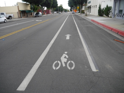
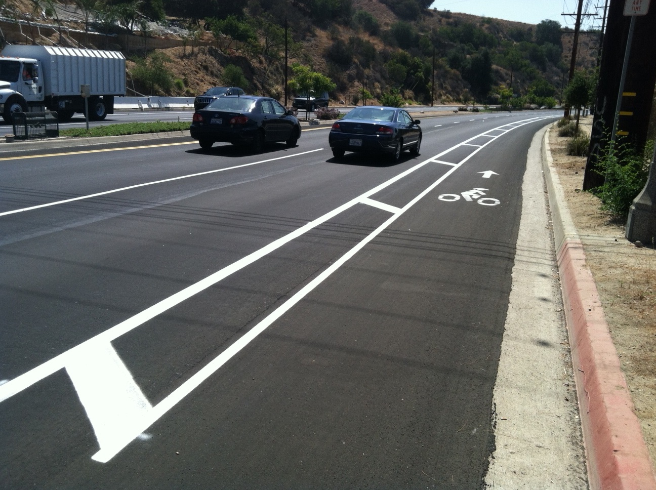
Pasadena recently painted new buffered bike lanes on Sierra Madre Villa in east Pasadena between Foothill and Orange Grove north of the Gold Line Station. This road diet improves safety along a notorious stretch of road, and provides buffered space for cyclists to ride to and from the retail and residential zones to the north of the station.  Some may recall that this blog has called for a road diet on this street, so it is nice to see the city make this street safer for all.

This safety improvement is especially important with the Metro Bike bikeshare program set to expand into Pasadena.  The retail area is still way too car-centric and these lanes abruptly end at Foothill and Orange Grove, limiting their usefulness for those who might not feel confident riding on those busy surrounding streets, but it is most definitely a step in the right direction, and Pasadena DOT and Councilmember Gene Masuda are to be complimented for their support for this project.

Southbound Sierra Madre Villa south of Orange Grove.

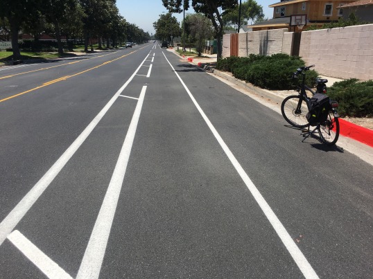
Northbound Sierra Madre Villa, north of Foothill Bl.


If bike lanes are extended north to Sierra Madre Blvd and South to Colorado Bl. extended east and west on Orange Grove and Rosemead Bl., a network of bike-friendly streets would exist for the first time in east Pasadena. Once this happens, the area would become bikeable not only for self-identified “cyclists,” but for everyone.  There is much latent demand for bike friendly streets in east Pasadena. There are parks, schools, offices, and a major shopping/dining area nearby. With the eventual addition of more transit-oriented development (TOD) around the Sierra Madre Villa Gold Line Station, the demand for walkable, bikeable streets in this part of Pasadena will likely grow.

The Bad:

Despite improvements such as Sierra Madre Villa, Pasadena still lacks a connected network of bike-friendly streets. Riding on N. Hill in central Pasadena recently (see photo), within the space of two blocks I was aggressively passed by two motorists, one of whom impatiently honked at me for good measure. I was legally riding on the right half of the right-hand lane, but there is no bike infrastructure on north-south streets in this part of town, and the low-level aggression from motorists makes the experience unpleasant for anyone on a bike.

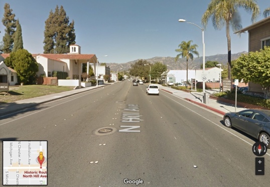
N. Hill, Pasadena. Parked cars on the shoulder forced me to ride the right-hand lane.


I brushed the incidents off as a “normal” part of riding in the city (I even gave the honking motorist a friendly wave), but the city cannot expect most people to feel comfortable on streets where they may be subject at any moment to vehicular harassment—or worse. The only way to accomplish this is to create a contiguous network of complete streets, well marked and intuitive to follow. This network must allow people to get to desirable destinations safely on foot or by bike.

Yes, education, encouragement, and enforcement are elements of a bike-friendly city, and I don’t suggest ignoring those, but the contrast between the streets with and without bike lanes shows there is no substitute for bike and pedestrian friendly infrastructure. In short, good things are happening in Pasadena, but we still have a way to go before city officials can claim city streets are “bike friendly.”


Dangerous Drivers, Dangerous Roads

Approximate spot where driver cut me off

Approximate spot where driver cut me off

This morning I was on my way back from my ride to my daughter’s school, about to stop off at the local Trader Joe’s to pick up some groceries.  I was on a four-lane stretch of road that is clearly marked as a “Bike Route” (see photo).  I took control of the right-hand lane as state law allows, because the shoulder was intermittently occupied by parked cars and trash bins and the lane was not wide enough for a car to safely pass (In compliance with CVC 21202, sec a3-4).  It was daylight on a sunny day and I had my rear flasher on for safety.  Visibility was not a problem.
As I approached the intersection, I could see a white mini-van gaining on me in my rear view mirror. At the last minute he passed dangerously close to me and then swerved back into my lane, cutting me off with about a foot to spare (violating CVC 21760).  It was a straight intimidation move, designed to send a message that I don’t belong on his roads.  His life-threatening driving got him to a red light at the intersection literally 2-3 seconds earlier than he otherwise would have.  He was a white male about 65-70 years of age with his wife in the passenger seat next to him.  When I got to the intersection, I pulled up to the passenger side of his car and matter-of-factly said that he needed to give me three feet (I may have been talking loudly, because his window was initially closed, but I was not being hostile, despite the fact that he had nearly killed me and my adrenaline–not to mention my anger–were running high). As I explained the law, he rolled down the window and told me that I was “in the middle of the street,” and that I have to “get over to the side of the road.”  I tried to explain that there were parked cars and trash cans that prevented me from doing so, and he growled “fuck you, asshole” and then immediately sped off when the light turned green.  His intimidation tactic won’t keep me off my bike, but drivers like him are an effective deterrent to many more people riding their bikes for everyday transportation.  Until we protect bicyclists from motorists like him, we won’t see significant changes in mode share.
It’s sobering to think there are motorists, licensed to drive by the state, who don’t know the law and would kill you to save themselves the trouble of easing their foot off the gas for a few seconds.  When I got to Trader Joe’s, my legs were wobbly from the realization of how close I had come to serious injury or death because of someone’s reckless, ignorant, entitled operation of a motor vehicle—a potentially deadly weapon.  Moreover, I’ve had another close call in the bike lane less than half a block from that spot.  The streets in that part of Pasadena are dangerous for cyclists because of high traffic speeds and a lack of good bike infrastructure.  The City of Pasadena needs to make it safer for bikes, but I’m sure DOT staff get tired of hearing me complain.
Will they wait until I, or someone else, get killed before acting?

Turn the Page

The new year provides an opportunity to look back on 2015 and ahead to 2016.  As always, it’s a blend of  disappointment that much-needed changes have been so slow in coming, gratification for the accomplishments, and hope for a continued shift in our transportation priorities in the future.  What is offered here is a highly personal, mostly local, list of the best of 2015 and some of my aspirations for bikes and alternative transportation in 2016.

The best of 2015:

  1. A shift in the conversation about climate change.  2015 may well be seen as the year the global community got serious about recognizing the necessity of radical action on climate change.  The Pope’s Encyclical on Climate Change, “Laudato Si,” provided a powerful moral argument for reducing carbon emissions while addressing the combined social and environmental injustices of the current economic model.  Then, in December, leaders of over 190 nation-states met at the Paris Climate Summit and agreed to commit their nations to voluntary reductions in greenhouse gas emissions. Pressure from citizen activists from around the world and from vulnerable nations elicited an “aspirational” goal of limiting climate change to 1.5 degrees celsius above pre-industrial averages.  While the agreement lacks any binding enforcement mechanism, it is an important starting point from which continued climate justice activism can and must proceed.  In order for these goals to have any chance of success, transportation sustainability (and equity) are going to play a role.  That means transit and bikes.
  2. Construction of Phase 1 Extension of the Gold Line from Pasadena to Azusa was completed.  The extension opens up possibilities for more transit choices in the San Gabriel Valley, and eliminates one more excuse for people who live nearby to go car free or car light.

    Bike parking at Arcadia station.

    Bike parking at Arcadia station.

  3. CicLAvia came to Pasadena!  The fun of cruising down a car-free Colorado Blvd. with thousands of other people still brings a smile to my face and reminds us why we must continue to push for more car-free space (temporarily or permanently) in our cities.  The car-free movement continued to spread in 2015, as iconic Paris opened its streets to people for a day in September. CicLAviaPas3
  4. New Bike Co-Op opened in El Monte.  BikeSGV’s new bike co-op, the Bike Education Center, provides a space for people from the local community to build or fix their own bikes.
  5. Metro’s Bike Hub at El Monte Bus Station. An important amenity for transit users who want a secure storage space for their bikes and a place for quick bike repairs right on the premises of the transit station.
  6. Pro-Bike Mayor elected in Pasadena.  The election of Terry Tornek as Mayor of Pasadena means that City Hall will continue to provide strong leadership for transit, walking, and bicycling in the city.
  7. Mobility 2035.  LA City Council passed an ambitious mobility plan that, if implemented, will provide more sustainable mobility choices for people in LA.
  8. Local bike infrastructure.  This is the weakest of 2015’s accomplishments.  But it is important to applaud any improvement.  For me, the bike lanes on First St. in Arcadia, near the new Gold Line station, even though they only stretch for about half a mile, are a sign that the city is trying to accommodate bicycle commuters.  Here’s hoping they are extended in 2016.

What I’m anticipating/hoping/wishing/working for in 2016:

  1. Gold Line extension opening, March 5, 2016.  This is a red-letter day for sure.  Looking forward to that first ride out to Azusa.
  2. Monrovia’s new bike plan.  Monrovia, at the behest of it’s local active transportation advocacy group Move Monrovia, has contracted with Alta Planning to produce a bike plan for the city.  I’m anxious to see the new plan and work with local advocates to make sure it gets approved and funded.
  3. Golden Streets 626: The San Gabriel Valley’s big open streets event, June 26, 2016 (i.e., 6.26)
  4. More bike lanes … everywhere.  Bike lanes are good.  Buffered bike lanes are better, and protected bike lanes (a.k.a. “Cycle Tracks”) are best.  I’m especially hoping to see some progress in Pasadena, Temple City, Arcadia, Monrovia. Et tu, El Monte?

    First Av. bike lane to Gold Line in Arcadia.

    First Av. bike lane to Gold Line in Arcadia.

  5. More bike racks (not the crappy, wheel-bender kind) … everywhere.
  6. Commitment from university administrators for a transit center on Cal Poly Pomona’s campus.  Cal Poly Pomona, where I teach, currently has no transit stop on campus.  Bus riders are forced to walk a long distance to sit on a splintered bench on Temple Ave.  Yet the University is building a multimillion-dollar parking garage and raising student parking fees.  Time for this otherwise “green” campus to make its transportation system green, too.

    What passes for a "transit center" at Cal Poly Pomona.

    What passes for a “transit center” at Cal Poly Pomona.

  7. Buffered bike lanes on Sierra Madre Blvd.  This has long been on my wish list.  There’s no reason it can’t be done.  The street is wide enough, the traffic speeds warrant it.  Hasn’t happened yet.  Still, I’ll keep asking ….

Happy car-light 2016 to all, and remember, there’s no such thing as a “green” car.  Whenever possible, leave your tin polluter box at home.  Be part of the solution, not part of the problem.  Walk, bike, take the bus or train.  It makes a difference!

Same Old, Same Old

Resurfaced Sierra Madre Villa, looking south.

Resurfaced Sierra Madre Villa, looking south.

When I see a street resurfaced, especially a street that desperately needs a bike lane, a glimmer of hope stirs within me that maybe, just maybe, the street will be restriped to accommodate bikes.  This foolish glimmer of hope is usually dashed, as the local DOT simply returns the street to the same old, unsafe car-centric design it had before.

Silly me.

Case in point: the recent resurfacing of Sierra Madre Villa Blvd in East Pasadena between Rosemead Blvd and Sierra Madre Blvd.

"Share the Road"

“Share the Road”

The street is marked as a “bike route” with a couple of “share the road” signs, but hardly anybody rides it because automobile speeds average about 40 mph, and it’s designed for automobile speed, not bike or pedestrian safety.  The street would require some minor re-design to accommodate bike lanes, as I’ll demonstrate below, but there is room for them and the street is a good candidate for bike lanes because it would close a gap between nearby streets that have bike lanes and it is the main route connecting the the neighborhood to the nearby Sierra Madre Villa Gold Line transit station.

This station is the major bus and light rail hub in the area, and is slated to be a bike share station when Metro eventually expands its bike share program to Pasadena.  You would think Pasadena DOT would use the resurfacing as an ideal opportunity to redesign the street for multimodal commuting and safety at minimal cost.  But you would be wrong.

On-street parking forces cyclists to "take the lane" in 40mph traffic.

On-street parking forces cyclists to “take the lane” in 40mph traffic.

Sierra Madre Villa Blvd is a north-south arterial that heads up the hill from the Gold Line station to New York Drive in Altadena (which has buffered bike lanes).  As it heads north, it intersects with N. Rosemead Blvd (which has bike lanes) and Sierra Madre Blvd. (which also has bike lanes). Currently, the street has 2 travel lanes in each direction (one 10-foot and 1 12-foot), a 10-foot center turn lane, and 2 10-foot parking lanes on each side.  The southbound side is residential with a library at Rosemead Bl.  The northbound side has an LDS church and an apartment complex, both of which have ample off-street parking.  The northbound side is the most critical for some kind of bike lane, because of the large speed differential between 40mph cars and bicycles heading up the hill.

Below I lay out the current configuration, then offer two alternatives: one that removes on-street parking from the northbound side and provides buffered bike lanes in both directions (option 1), and another that keeps on-street parking but narrows the parking lane and one of the 12-foot travel lanes to provide sharrows on the downhill side and a bike lane on the northbound side (option 2).  Neither one of these options would have been cost prohibitive.

SMV Current

SMV option1

SMV option 2

Why didn’t DOT consider more bike friendly alternatives for Sierra Madre Villa, especially considering their stated desire for Pasadena to rival Long Beach for bike friendliness?  I have several theories, but one is that DOT staff tends to pay more attention to bike infrastructure in the gentrifying downtown area than in East Pasadena, a less glamorous part of town.

It’s a shame, because this was a real missed opportunity.  DOT needs to know that people on bikes in East Pasadena deserve safer streets, too.

The Close Pass

California’s new “3 Feet for Safety” Act, which requires motorists to give bicyclists 3 feet when passing, went into effect last month.  While most motorists seem to be abiding by the new law, I’ve had a couple of close calls the last few weeks that suggest motorists could use a bit more education on how to safely pass cyclists.  The fact that both incidents occurred on the same stretch of roadway in Pasadena also seems to strongly suggest that this road needs additional infrastructure treatment (i.e., a “road diet” that narrows the traffic lanes and buffered or protected bike lanes) to slow the speed of traffic and provide safe space for bicyclists.

Drivers encroach on the bike lane on Rosemead Blvd at 40 mph. At least half of the cars in the right lane crossed into the bike lane on the morning I took this picture. A buffer and green paint in the lane would increase safety, as would a reduction in the 40 mph posted speed limit.

Drivers encroach on the bike lane on Rosemead Blvd at 40 mph. At least half of the cars in the right lane crossed into the bike lane on the morning I took this picture. A buffer and green paint in the lane would increase safety, as would a reduction in the 40 mph posted speed limit.

The first close call came a couple of weeks ago when I was traveling south on Rosemead Blvd in the bike lane between Sierra Madre Villa and Halstead.  The road curves to the right and as I rounded the curve, a driver in a Honda Civic passed me so close I could feel the wind from her passenger-side mirror brush my left arm, which startled the hell out of me.  Her right tires were actually on the bike lane line.  She was probably doing about 40 mph, and as she passed I involuntarily yelled out of fear.  I tried to catch her, but she was going too fast and I got stopped at the red light on Rosemead and Halstead.  As she sped away, she seemed to slowly drift in her lane from left to right and back.  Was she drunk (this was a Monday morning about 10:00 am)? On meds? Texting?

The second incident occurred last Friday afternoon about 1:30 pm, traveling southbound on Rosemead again, this time between Halstead and Hastings Ranch Road.  On this stretch of Rosemead there’s no bike lane, as it ends at Halstead.  There is a shopping center with a new L.A. Fitness center that opened recently, and now that it is open, there are many more cars parked on the street here.  This forced me to ride in the traffic lane, as the curbside shoulder is now occupied by the cars of people working out at the fitness center.  How ironic that people park their cars on the street here, despite the fact that there is plenty of parking in a lot behind the fitness center, but drivers would have to walk maybe 100 feet farther to the entrance to the gym if they parked in the lot (better to save your walking for the treadmill you’ve paid for inside the gym, huh?).  Meanwhile, the presence of their empty cars in the street creates a hazard for those using alternate modes of transportation.  There would be plenty of room for bike lanes here if Pasadena DOT prohibited on-street parking here, but clearly the safety of cyclists is not a priority.


Parked cars (mostly for the fitness center on the right) force bicycles into the fast-moving traffic lane. Pasadena DOT could make this a no parking zone and have plenty of room for buffered or protected bike lanes here.

Parked cars (mostly for the fitness center on the right) force bicycles into the fast-moving traffic lane. Pasadena DOT could make this a no parking zone and have plenty of room for buffered or protected bike lanes here.

As I rode in the right-hand traffic lane and tried to avoid the “door zone” (about three feet away from the parked cars), a driver in a compact sedan sped by me at high speed and far too close for comfort.  This time, I caught up to the driver as she sat at the next red light.  Her passenger side window was closed, but I leaned over and said loudly (my adrenaline was up from the close call), “you need to give cyclists three feet when you pass.”  She rolled down her window and apologized (which surprised me). She explained that another car had been passing her in the lane on her left when she passed me, so she couldn’t move farther to the left as she passed.  I thanked her for her honesty, she apologized again, then the light turned green and she took off.

At least the exchange was cordial, but as I rode on, I thought to myself, “if it wasn’t safe for her to move to the left to give me space, shouldn’t she have just slowed down for (at most) a few seconds until it was safe to pass?”  The answer is obvious, of course she should have.  This is an aspect of driving that most motorists don’t think about when passing a person on a bike.  People are often in a hurry, so they figure they’ll just squeeze by.  Squeezing by another motorist when you’re both wrapped in 2,000-lbs of steel is not perceived as a problem.  Worst that might happen is scratched paint.  Squeezing by a bicyclist is a life-threatening move for the bicyclist.

According to the California Vehicle Code, bicyclists are allowed to “take the lane” if it is not safe for a bike and a car to pass side-by-side, and I probably should have been smack dab in the center of the travel lane rather than riding on the right half of the lane.  It would have forced motorists in my lane to slow down behind me.  Yet, few things irritate drivers more than cyclists “hogging” the lane.  Hey, it’s not a picnic for me.  I don’t like to slow others down and I don’t like the feeling of a car running up behind me, either.  A recent study by the League of American Bicyclists found that the largest portion of car-on-bike fatalities were cars hitting bikes from behind.  Nor do I relish being honked at or yelled at by impatient motorists who don’t give a shit about my right to the lane.  But, it’s probably safer than having a driver try to pass me too close when there isn’t enough room.

This raises a larger point I made earlier about the lack of bike lanes (including protective buffers between cars and bikes) on high-speed arterials like Rosemead Blvd.  There’s plenty of space.  For one thing, there’s no need for on-street parking when the adjacent shopping center has an ample off-street parking lot.  Buffered bike lanes or cycle tracks (bike lanes with physical separation from automobile traffic) could be installed on the shoulder of the road where empty cars now sit and it would not impact traffic flow.  Further south on Rosemead, the city of Temple City has already installed cycle tracks.  It’s time for Pasadena to do likewise.  At the very least, the Pasadena DOT should ban on-street parking on that stretch of Rosemead so bicyclists can safely use the shoulder out of the way of speeding cars.  The fact that I’ve had two close calls on the same stretch of roadway indicates the street is not safe.  There’s too little space for bikes and cars are driving too fast.

I’m glad the 3-foot passing law is now in effect in California, but we still need better education on how to pass a bicyclist safely and, most importantly, protected bike lanes on more of our streets.  What do you say, Pasadena?

Buffered Bike Lanes!

NYE Bike Lane

You know you’re a bike geek when the appearance of new buffered bike lanes on a local street makes your day.  In this case, Pasadena DOT has at long last upgraded the bike lanes on New York Drive between Altadena Drive and Sierra Madre Blvd to buffered bike lanes.

The addition of a painted 2-foot buffer zone between the bike lane and the traffic lane is especially important on this stretch of NY Drive insofar as cars travel at about 50 mph.  That’s right, 50.  On the downhill stretches of the road, motorists are sometimes going even faster.

The first time I rode the old bike lanes on NY Drive (about 4 years ago) was the last.  There’s nothing like the terrifying feeling of a car or truck passing within a couple of feet of you doing 50 mph or more.  It’s enough to make all but the most hard core cyclist say “fugettaboudit.”  Today, on the other hand, I rode in the buffered lane and felt much more comfortable.  The 2 additional feet of space between you and speeding automobile traffic may not seem like much, but, believe me, it makes a huge difference.  Now I feel more comfortable taking this route to visit friends and family in the Eaton Canyon area of Altadena and it cuts a good 8-10 minutes off of the longer route I used to take to avoid what had been an awful stretch of road to ride on.

The weak link: cars parked on the shoulder require bikes to enter travel lane where cars approach 50 mph.

The weak link: cars parked on the shoulder require bikes to enter travel lane where cars approach 50 mph.

While the buffered lanes are a major improvement, the route is still not completely safe.  Unfortunately, the bike lane abruptly ends and DOT left the shoulder of the roadway open to parked cars for the 4/10ths of a mile between N. Altadena Drive and Eaton Canyon Drive (in front of swanky Gerrish Swim Club).  During the summer months and on weekends there are often long lines of parked cars along the entire stretch, forcing bicycles into a traffic lane where cars are moving at upwards of 50 mph.  Moreover, on the westbound side, the road pitches uphill steeply, meaning bikes traveling this portion will be going slow, unless being ridden by a Tour de France-level athlete.  So with the sudden loss of a bike lanes and parked cars, you go from tolerable comfort and safety level to super high-stress, unsafe roadway.

As such, I give the stretch with the buffered lanes a B+ (because of the high traffic speeds, some plastic bollards along the outer edge of the buffer would earn an A- and a curb-protected bike lane would earn an A), and I give the stretch between Eaton Cyn Drive and Altadena Drive as currently designed an F.  Because of the prioritization of curbside parking for cars, I still wouldn’t feel comfortable recommending this stretch of the route for kids, newbies, or less confident riders, and thus it fails the “8-80” test (i.e., is it safe for cyclists from 8 to 80?).  If we want to get more people out of their cars, a bike route is only as good as its weakest link, and I fear this design flaw will not make the route more popular with people who don’t already ride.

Uphill section much improved by buffered lanes.

Uphill section on eastbound side of New York Drive is much improved by buffered lanes.

Overall, however, I have to say that the buffered lanes are huge improvement over the non-buffered lanes that existed before.  On the eastbound side, as I rode the uphill stretch going much more slowly, the buffered lane made a big difference.

What a change 2 feet make.  We still have a long way to go, but we’re making progress.  Here’s hoping Pasadena DOT fixes the weak link on this road and continues to add more buffered bike lanes to more streets.

Small Steps?

BikewayStudyMTG

Could the city of Pasadena finally be close to adopting an ambitious mobility plan?  This week, my friends at the Pasadena Complete Streets Coalition (PasCSC) attended meetings with city officials to provide feedback on elements of a new mobility plan that, if implemented, will make getting around Pasadena on foot and by bike much easier and safer.  The first of those meetings was a preview of potential new bikeways in Pasadena.

A year ago, in the wake of the tragic death of cyclist Phillip O’Neill in the city, a group of local advocates met and formed PasCSC to lobby for safer streets for all road users (“complete streets”).  As part of that effort, the group was critical of the Pasadena DOT’s draft mobility plan as not going far enough to make Pasadena bike and pedestrian friendly.  Several members of the City Council, including Mayor Bill Bogaard and Councilmember Terry Tornek, called on DOT to revise its bike plan and “be bold.”

On June 24, community members got a sneak peek at a “Bikeway Analysis and Feasibility Study” that assessed the feasibility of major street redesign on up to seven east-west corridors and four north-south corridors in Pasadena.  The study was conducted by KOA Corporation, a transportation planning and engineering firm that has designed, among other things, the highly regarded 3rd Street and Broadway Cycle Track in Long Beach and the new Rosemead Cycle Track in Temple City, the first of its kind in the San Gabriel Valley.

Temple City's cycletrack on Rosemead Blvd. (photo: StreetsblogLA)

Temple City’s cycletrack on Rosemead Blvd. (photo: StreetsblogLA)


Cycle tracks are essentially bike lanes protected by a physical buffer, such as a curb, landscape planters, or parked cars.  They are common in Europe and have just begun to be used here in the US.  They are, if you’ll excuse the automobile metaphor, the Cadillac of bike lanes.  Rich Dilluvio, senior transportation planner for Pasadena’s DOT (see photo, top), asked the advocates for feedback and to prioritize the proposed routes that would be most valuable to cyclists as the initial backbones of a bike-friendly Pasadena.  Planners wanted to know, in other words, in case they’re not all funded at once, which ones did bicyclists want to be completed first?  I confess, I want them all—now, but I know that it will take time to work its way through the political process, the community outreach process, the funding process, and finally, the construction process.  I also realize they may not all be funded immediately.  The sooner we get them, though, the better for active mobility and traffic safety in Pasadena.

Readers will know that I’ve been critical of Pasadena’s previous bike plan, but my initial response to these new proposed bikeways is cautious optimism.  The east-west routes are especially ambitious, including plans for separated, bi-directional bike lanes on Green and Union, as well as proposed cycle tracks or buffered bike lanes on other routes. The north-south routes are a bit more difficult because they need to be routes that cross the 210 freeway (the huge concrete traffic sewer that cuts through the heart of Pasadena like a jagged gouge carved out of the city’s midsection) and don’t have high traffic volumes.  These constraints limit north-south routes, and they tend to be narrower streets.  For these north-south corridors, KOA Corporation engineers have proposed four “bike boulevards” that will be designed to minimize automobile volume and speed, and prioritize bicycle travel.  Similar treatments have been done on streets in Portland and Minneapolis, two of the most bike-friendly cities in the US.  A pilot for such treatment has also been implemented on Pasadena’s North Marengo Ave. between Orange Grove and Washington.  In addition, DOT director Dilluvio indicated that several existing streets with bike lanes are slated to be repainted with buffered bike lanes when they’re up for resurfacing.  Buffered bike lanes increase a cyclist’s comfort and safety by providing a painted “buffer zone” between the bike lanes and other traffic lanes.

This proposed network of bikeways is not perfect.  Several advocates noted that the planners seem to have paid little attention to modifying intersections.  Most collisions take place at intersections, and less experienced bike riders who feel comfortable in a protected bike lane mid-block will find themselves unprotected when they get to busy intersections.  This may reduce potential ridership, and hence the purpose of the protected bike lane.  Also, there was apparently little effort to choose key corridors that would directly connect with any of the city’s six Metro Gold Line stations, meaning commuters, shoppers, or visitors who take the Gold Line won’t be right next to the best bike routes to and from Gold Line stations.  There are still gaps: Northwest Pasadena and East Pasadena get little attention, though these bikeways are only part of the larger bike plan.  Finally there has, as yet, been little thought given to a system of wayfinding signage to help bicyclists navigate the proposed bike-friendly network of routes through town.  I am hopeful that there will be opportunity to address these issues when the entire bike plan comes up for public comment.

I have to say that these proposed bikeways, if they are funded and constructed, have the potential to be a significant step in the right direction for Pasadena, making the city a leader in active transportation in the San Gabriel Valley.  Soon it will be time for Pasadena’s elected officials to resist the inevitable boo-birds and anti-bike lane NIMBYs who will oppose any change in the current car-centric design of Pasadena’s streets and approve these proposed bikeways.  PasCSC will have to mobilize its supporters to provide support for the plan.  A healthier, safer, greener, even happier city awaits this pending test of community mobilization and city leadership.

Car-Centered Culture at CalTrans

Bicycle and alternative transportation advocates often lament that state and local departments of transportation (DOTs) seem locked in a time-warp with regard to road design.  Many DOTs continue to privilege the level of service (LOS) to automobiles, regardless of how it impacts the safety or ability of pedestrians, bicyclists, and transit users.  In short, they continue to design roads for cars, as they have since the 1950s, despite the fact that multimodal transportation solutions are essential if we are to address the interconnected problems of gridlock, road safety, public health, pollution, sprawl, and climate change.

Thus it was with some interest I read a new report assessing how well CalTrans is meeting the multimodal needs of California in the 21st century.  The report’s authors, to put it bluntly, excoriated CalTrans, accusing the agency’s transportation policies of being woefully “out-of-date” and the department itself ossified by a “culture of fear” that looks with suspicion on innovation.  The report accuses CalTrans of operating under “an anodyne mission that might have been written in the 1950s.”  CalTrans, said the report’s authors, continues to privilege automotive LOS while ignoring other measures of multimodal road usage, and has failed to align its policies with California’s laws encouraging transportation design that reduces dependence on the automobile and GHGs.  Indeed, the report noted that the word “sustainability” does not show up once in the department’s most recent guide (indeed, the word was apparently struck from the final version).  Perhaps most damning was the picture painted of a culture in CalTrans not only resistant to change, but apparently hostile to it.

This reaches into every community, insofar as CalTrans’s Highway Design Manual is frequently followed by cities as a standard for roadway design.  The current HDM does not incorporate modern best practices that enable cities to design roads to accommodate multiple road users, such as bicycles.  The report notes that, according to CalTrans’s HDM lane widths are set too rigidly, often preventing innovative road designs that might better accommodate bicycles:

The “mandatory standards” for lane width and shoulder width are high—12-foot minimum lane widths are generally required, with 11‐foot lanes allowed in a few limited circumstances. In contrast, off high-speed limited access highways, current best practice nationally calls for lane widths of 10‐12 feet, depending on the context. (p. 30)

The report’s authors also note that CalTans standards prioritize high automobile speeds on such roads, despite the deleterious effects on other non-automobile road users:

The manual’s approach to motor vehicle design speed, which does much to determine the character of a road or street, favors high speeds without regard to their impact on other modes. (p. 31)

The report’s findings are significant for a number of reasons.  First, wider lanes have been shown to induce motorists to drive faster, which increases road danger, and creates an intimidating environment for bicyclists and pedestrians.  For example, on Sierra Madre Blvd., a divided road in Pasadena (under the jurisdiction of Pasadena DOT) with 12-foot wide lanes and a substandard (4 ft-wide) bike lane, the traffic speeds are posted at 40 mph.  The wide lanes encourage high traffic speeds, making the road less safe and intimidating for bicyclists when drivers zoom by, despite the bike lane.  It is no wonder more youth and families don’t ride their bicycles to nearby Pasadena High School and LaSalle High School or to nearby shops.  The report also notes that CalTrans’s standards effectively discourage communities from installing protected bike lanes through innovative use of curbs, bollards, planters, or other barriers that would insulate bicyclists from high-speed automobiles.

Yet, on Sierra Madre Blvd., there is plenty of room on the roadway to widen the bike lanes, making them safer and encouraging more people to ride.  Measuring the road width, I produced a mock-up of that section of road (top image, shown below), using the open website streetmix.  Note that as currently configured, the bike lane forces the bicyclist into the “door zone” of parked cars on the right as with little room to protect her from the speeding traffic on the left.  Not only that, the current road design actually provides a wide buffer along the center divider, and not the bike lane.

SMBlvdWB_unimp

On the other hand, if the lane widths were reduced to 10 ft, or even 11 ft, as allowed by the most up-to-date transportation design manuals used in some other states, it would provide at least three additional feet that could be used to widen the bike lane and perhaps provide a painted buffer between cars and bikes, increasing safety and comfort for all (see same street view modified below).  However, as long as California’s state standards prescribe 12-ft lane widths, local governments will be loath to change.

SMBlvdWB_current

I ride the above route to school with my daughter every week, and I would like the street to be safe enough for all the high schoolers who live nearby to ride their bikes to school.  It would reduce traffic, reduce pollution, reduce GHGs, and improve the health of the community.  This road could easily be redesigned, with no inconvenience to motorists, other than perhaps slowing down 5 mph.  But we need state and local DOTs in California to get their heads out of their a—–, uh, get with the program.

The independent reviewers recommend a significant change in the culture of CalTrans away from the auto-centered perspective that has dominated the department since the 1950s:

Modernization of Caltrans will require a difficult conversation about the conflict between mobility, as conventionally understood, and sustainability, which is not yet well understood by the department at all. Mobility [for CalTrans] has meant facilitating more and faster travel, particularly by automobile. While sustainability … means looking for ways to meet Californians’ needs without increasing auto travel and speeds. (pp. 39-40)

The report’s diagnosis certainly confirms my own frustrating experience with an out-of-date, auto-centered street infrastructure in most of the communities where I ride.  But its diagnosis raises the hope that things may be changing.

Post Navigation